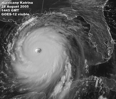
Hurricane Katrina movie (12 MB QT) 24-29 August 2005
Hurricane Katrina in the Gulf (1 MB GIF) 28 August 2005
REAL TIME
Full-Disk Gallery (click for this real time page)
http://images.google.com/imgres?imgurl=http://rsd.gsfc.nasa.gov/goes/pub/goes/010911.erin.towers.gif&imgrefurl=http://rsd.gsfc.nasa.gov/goes/text/hotstuff.html&h=748&w=1287&sz=654&tbnid=IgL5eNDO4ybrkM:&tbnh=87&tbnw=150&hl=en&start=52&prev=/images%3Fq%3D9/11%26start%3D40%26imgsz%3Dxxlarge%26svnum%3D10%26hl%3Den%26lr%3D%26rls%3DGGLG,GGLG:2006-10,GGLG:en%26sa%3DN
2006
Midwest storm floods New England (12 MB QT) 14 May 2006
52 Tornados in 24 Hours (5.3 MB QT) 8 April 2006
Midwest Tornado Outbreak (5.4 MB QT) 12 March 2006
Lake-Effect Snow Fields (1.6 MB GIF) 7 March 2006
Mid-Atlantic snowfall (0.6 MB GIF) 13 February 2006
Recent GOES Full Disk Images this page last updated 6 September 2004 NOAA broadcasts a GOES full-disk scan once every 3 hours. An automated site at NASA-GSFC captures them, converts the GOES satellite data into images, and puts the digital pictures on the web. This page links to those full-disk pictures of the Earth in several formats, enhancements, and resolutions. For full-resolution images of small sectors, see the links on the GOES Project Science Page.
COLORFUL GOES-EAST PICTURES (1200 pixels by 1000 lines, JPEG compressed, ~0.3 MByte downloads) Red = visible channel, Green = 11 micron infrared channel, Blue = 4 micron infrared channel.
COLORFUL GOES-WEST PICTURES (1200 pixels by 1000 lines, JPEG compressed, ~0.3 MByte downloads) Red = visible channel, Green = 11 micron infrared channel, Blue = 4 micron infrared channel.
RECENT GOES-EAST IMAGES (1200 pixels by 1000 lines, greyscale TIFF format, 1.2 MByte files) NOTE: "IR4" is the thermal infrared image, which lets you see the entire Earth by its own glow at any time of day.
RECENT GOES-WEST IMAGES (1200 pixels by 1000 lines, greyscale TIFF format, 1.2 MByte files) NOTE: "IR4" is the thermal infrared image, which lets you see the entire Earth by its own glow at any time of day.
FTP: GOES-EAST HIGH-RESOLUTION RAW DATA (IR 3300 pixels by 3002 lines -> 10 MByte IR files) (VIS 13200 pixels by 12008 lines -> 168 MByte VIS files) HINT: this data is best rendered using Adobe Photoshop.
FTP: GOES-WEST HIGH-RESOLUTION RAW DATA (IR 3300 pixels by 3002 lines -> 10 MByte IR files) (VIS 13200 pixels by 12008 lines -> 168 MByte VIS files)
HINT: this data is best rendered using Adobe Photoshop.
TECH NOTE 1: Local midnight and noontime roll-overs occur several hours into Universal Time (UTC, aka GMT, aka Z, aka Greenwich time, aka London time):
midnight EST = 1 am EDT = 0500 UTC; noon EST = 1 pm EDT = 1700 UTC midnight CST = 1 am CDT = 0600 UTC; noon CST = 1 pm CDT = 1800 UTC midnight MST = 1 am MDT = 0700 UTC; noon MST = 1 pm MDT = 1900 UTC midnight PST = 1 am PDT = 0800 UTC; noon PST = 1 pm PDT = 2000 UTC
TECH NOTE 2: Most of our files have time-stamp names in odometer-style Universal Time, "YYMMDDhhmmSatChan.TYPE". For example, "0312311745G08I01.TIFF" is decoded as: - year = 03 (2003) - month = 12 (December) - day = 31 (the 31st of the month) - hour = 17 (12 noon + 5 pm Universal Time in London, England) - minutes = 45 (:45 minutes after the hour) - Satellite = G12 (GOES-12, aka GOES-EAST) - Channel = I01 (Imager channel 1, aka visible) - Type = TIFF (Tagged Image File Format)


No comments:
Post a Comment