Showing posts with label catastrophes. Show all posts

May 28, 2008

Earthquake articles (recent)

Earthquakes can trigger others half way around the world

May 25, 2008
AP

A major quake such as the one that left at least 60,000 dead in southwestern China this month can trigger other earthquakes half way around the world, according to a study released Sunday.

This unexpected finding could one day help make better predictions about the frequency and intensity of aftershocks, the lead researcher told AFP.

A team of geologists in the United States found that 12 out of 15 major quakes -- registering a magnitude of 7.0 or higher -- since 1990 generated surface waves that set off smaller seismic events in fault systems on distant continents.

The China quake, which measured 8.0 on the Richter scale, was not included in the study, which was published in the British journal Nature Geoscience.

"It was known that these surface waves could travel," explained co-author Tom Parsons of the US Geological Survey.

"But most scientists thought these so-called dynamically-triggered earthquakes were a special case. In fact they happen all the time, everywhere, and that was something of a surprise," he said in a phone interview.

The terrible December 2004 mega-quake off the coast of Sumatra, Indonesia, for example, provoked seismic events as far away as Alaska, California and Ecuador.

There is a better than 95 percent likelihood that the earthquake rate in distant areas will be much higher in the immediate aftermath of a big quake than before or after, the study found.

And while the seismic movements triggered by far away quakes were generally smaller -- in the three-to-five magnitude range -- there is no reason they could not be as big or bigger than the first.

"They could be any size," said Parsons, who in previous research identified eight cases in the last quarter century in which a 7.0-or-bigger earthquake led to another that was even larger.

To measure the impact elsewhere on the planet of major tremblors, Parsons and colleagues analysed broadband seismographs from over 500 stations, part of a worldwide monitoring network.

By searching for the lowest frequencies and filtering out the highest, they detected a sharp increase in the number of distant quakes triggered by a main quake, even though the tectonic environment of the two regions were independent.

"The big question is aftershocks, and what happens after you have a big earthquake," said Parons, adding that there are two competing theories as to how such follow-on quakes are unleashed.

Static triggering occurs within a few fault lengths of the main rupture, often in a cascading effect. But impact generally peters out beyond a 100-to-200 kilometre (70-to-140 mile) radius.

The spike in quake activity further afield can only be explained by dynamic triggering, explained Parsons.

Such seismic waves travelling along the surface of the earth "keep their amplitude and do not diminish that much even over great distances," he said.

The key to predicting the aftermath of a quake such as the one in China will be teasing apart the role of static and dynamic triggering.

"We can look at the aftershocks and start to learn, but we need to know what percentage of those are dynamically triggered because the effect isn't lasting, it's transient," Parsons explained.

"Once those waves are gone, the effect is mostly over with, we really don't have to worry about that any more."

http://www.breitbart.com/article.php?id=080525173254.8uczuvwc&show_article=1

Study: Large Earthquakes Do Trigger Other Quakes


May 25, 2008
Ed Yeates reporting
KSL TV5

Everybody has theorized about it for years, but now there's proof! Large earthquakes do, in fact, trigger other earthquakes, sometimes on the opposite sides of the Earth.

In 1992, a magnitude 7.3 earthquake hit Landers, Calif. Within minutes and hours of that Lander's event, a quake rattled Las Vegas. Then 60 small quakes broke loose near Cedar City. Quakes also hit two volcanic locations on California's Cascade Range. And quakes showed up in old craters in Washington state and Yellowstone Park.

Scientists had believed large quakes cannot trigger other quakes hundreds of miles away, but apparently, they can. In fact, University of Utah seismologist Chris Pankow and her colleagues, who've carefully analyzed two different kinds of surface shock waves from 15 major earthquakes over the past 16 years, say the triggering occurs not only hundreds, but thousands of miles away.

Chris Pankow, a University of Utah seismologist, says, "What we clearly found from the Sumatra earthquake is a triggered event in Ecuador, which is at the antipode - so opposite side of the globe - there was triggering."

The triggered earthquakes are smaller, but they happen globally and sometimes in areas not prone to earthquakes. So, why are some faults triggered by a distant event? One theory, Pankow says, is "You have something really ready to go, and you just put a little energy, and that sort of accelerates the time on the fault to failure."

Another theory says shock waves shake the pores loose in geothermal areas like Yellowstone Park or places with a high water table. In some cases, increased fluid pressure may actually lubricate a fault, so it slips a bit.

Seismologists don't know for sure what's happening on the receiving end, but now that they do know triggering occurs, they'll move to the next step, hoping to understand the mechanics. "It's happening everywhere following large earthquakes, and that is exciting and really interesting to me as a scientist," Pankow said.

Another possibility: could a different kind of earth mechanics, involving what seismologists call static stress, affect our own Wasatch fault? One 25 mile section of the fault breaks loose with a magnitude 7 or greater earthquake, triggering yet another quake on another section of the fault. It could happen!

The University of Utah partnered with the University of Texas and the United States Geological Survey for this landmark research. The full study appears today in Nature Geoscience.

http://www.foxnews.com/story/0,2933,354692,00.html


Moderate quake hits Panama-Costa Rica border

Mon May 26, 2008 5:33pm BST
[-] Text [+]

PANAMA CITY (Reuters) - A moderate earthquake of 5.2 magnitude struck on the Pacific coast side of the Panama-Costa Rican border on Monday, the U.S. Geological Survey said, but only minor structural damage was reported.

The quake, which hit at 10:01 a.m. local time (4:01 p.m. British time), was centred 135 miles (217 km) southeast of San Jose, Costa Rica, and at a depth of about 22 miles (35 km), the USGS said.

The only initial report of damage was of cracks in the walls of a school in the Baru region of Panama, near the country's only active volcano, a spokeswoman for Panama's civil protection service said.

(Reporting by Andrew Beatty; Editing by Eric Beech)

International Herald Tribune
Suspense and dread as Chengdu waits for the next tremor
Tuesday, May 27, 2008

CHENGDU, China: The teahouses are nearly empty, travel agents sit beside silent telephones and shopkeepers pass the day watching the ongoing agony of their countrymen on television. The buildings in this usually teeming city of 10 million, about 80 kilometers east of the epicenter of the May 12 earthquake, may be unscathed, but its residents are living on edge.

"Everyone is paralyzed with dread, and each new tremor just prolongs our misery," said Wu Longyou, a crafts vendor presiding over a nearly deserted outdoor shopping mall that normally pulses with foreign tourists. "We are still alive, but we are suffering too."

The powerful aftershock that struck northern Sichuan Province on Sunday sent thousands of residents here running into the street. There was little damage in Chengdu, but the aftershock, with an estimated magnitude of 6.0, killed at least 8 people, injured more than 400 and toppled 70,000 buildings in the mountains to the north, according to the government.

It also renewed the terror for millions of earthquake survivors who are living in tent camps, subsisting on instant noodles and waiting for the earth to stop shaking. On Monday, government officials issued fresh warnings that 69 fragile dams and several rivers blocked by mammoth landslides were looming threats to tens of thousands of people living downstream. On Tuesday, they raised the death toll from the May 12 earthquake to more than 67,000.

Here in Chengdu, the provincial capital of Sichuan, each new tremor rattles the collective psyche of a city that escaped serious physical damage but has lost its joie de vivre. Local officials estimate that as much as a third of the population has left town; many of those who remain spend their nights in tarp-and-tent shantytowns.

Those with the means drive out to the countryside and bed down in their cars. "I don't want to die in my sleep," said Dan Chao, 13, explaining why he and his parents refuse to spend the night in their third-floor apartment.

Chengdu is in a stranglehold of fear. On May 19, a week after the earthquake struck, a local television station broadcast a warning just before midnight that a 6.7 magnitude aftershock was on the way.

Streets quickly clotted with fleeing vehicles and parks filled with families and their bedding. The big aftershock, however, never came.

For the last two weeks, students at Sichuan University have slept in their track suits; many keep their dormitory room doors open to allow for a quick escape. "We joke that it would be embarrassing to have to run outside in our underwear, but actually I think we are all afraid," said Deng Minkuei, 19, a sophomore, who, like most of his classmates, keeps a knapsack with water and biscuits by the door. "To spend two weeks waiting for another earthquake is not good for your health."

While government officials say the earthquake's impact on the national economy will be small, the toll on Chengdu is expected to be enormous. The city is a tourist gateway to ancient monasteries and a world-famous panda reserve, which sit at the heart of the disaster zone. Tour operators say business, even in parts of the province untouched by the earthquake, has disappeared.

"After they see the news, no one wants to come here," said Yu Jia, a Chengdu travel agent sitting glumly at his desk. "Everything is dead. Maybe it will be like this for a year."

Many of the city's hotels are nearly empty, although a few of the newest ones - those that claim to be "quake resistant" - have seen an influx of journalists and foreign relief workers.

Wu Longyou, 40, an artisan who weaves palm fronds into the shapes of insects and animals, said he had barely made any money since the quake struck. This week he is heading to Hangzhou, a city more than 1,400 kilometers, or 900 miles, to the east, where there are plenty of tourists. "If I stay here any longer I'm going to starve," he said.

Not everyone is complaining. Xu Jianquan, who runs a local real estate company, said business had been brisk, although most people were seeking apartments in new buildings.

As he spoke, two men sat in his office making a deal for a rental unit in a building constructed in 1990. The prospective tenant, Zhen Deyun, said he would have preferred a ground-floor apartment in a modern building but decided the third floor would have to do.

"From what I can tell, it's relatively good construction," said Zhen, 38, a stock analyst, who, along with his mother, is moving from an older building on the city's outskirts. "Of course, if an 8.0 magnitude earthquake hits Chengdu, nothing will be safe."

Such insecurities play out in unpredictable ways. High-end hair salons and massage parlors say they have seen a slight rise in customers seeking to be pampered, while stores that sell alcohol say business is off by a third. "Maybe people don't feel like celebrating, or maybe they don't want to be drunk when an earthquake comes," said one liquor store clerk, standing in an empty shop.

Wu Min, 43, a lottery ticket vendor, had her own theory for why sales were down by half. "When people are anxious or in a bad mood, they will not pick good numbers," she said. "They are just waiting for the aftershocks to stop."

So, too, are the hundreds of people who have turned the leafy promenade along the Funan River into a cavalcade of red, white and blue tarps. Tan Yuquan and his neighbors have stocked their encampment with beds, plastic chairs, playing cards and mosquito coils. The mood was buoyant Monday night, with neighbors chatting late into the night as children ran up and down the sidewalk. "It makes us all closer," Tan, 60, a candy salesman, said as he passed out cigarettes to the crowd.

His wife, Hou Xiaorong, 42, was less sanguine. After two weeks, she said she was growing weary of the lack of privacy and the noise from cars passing a few meters from their pillows.

"I guess it can always be worse," she said. "Living on the street isn't so great, but it's better than waking up with a building falling on your head."


Visions of New Madrid Quake


Pastor John Kilpatrick
watch@churchofhispresence.org
Daphne, Alabama


Sunday, April 27, 2008 - Vision

As I was approaching the Daphne Civic Center for Sunday morning service at Church, I had a vision which lasted for about two or three seconds. In this vision, I saw the ground buckling before me. It was so real that I actually moved aside to avoid what I was seeing. I knew immediately that it was an earthquake, and the thought crossed my mind that the damages of this earthquake could have the potential to exceed those of Hurricane Katrina of 2005.

WIND and WATER

May 20, 2008

I awoke trembling at 5:00 in the morning after having a startling dream. This was one of the three most profound dreams that I have ever had during the ministry the LORD has called me to. I feel that this dream is an addendum to the vision I had on April 27, 2008.

I saw the words wind and water. I only saw the words but did not actually see any wind or water damage. I then found myself overlooking a river which instantly became so wide that I could no longer see either of its banks. The dream then shifted, and I was with one of my parishioners running through what appeared to be an old abandoned school house. This empty building began to shake. The shaking was so violent and severe that it was like the bucking of a wild horse tossing us around. My teeth were clapping so hard from the impact that I tried to clinch them to prevent this from happening.

In this dream I knew I was experiencing a massive earthquake. The sounds were so catastrophic that the thought crossed my mind that the devastation could likely exceed Hurricane Katrina of 2005. I did not see the devastation behind me, I only heard it. In all of my life I have never heard such catastrophic sounds. These were the scariest sounds I have ever heard. The dream then shifted once more and concluded with two names on what appeared to be an old Spanish map. One name read Indianola and the other Europa.

I researched the internet and contacted some close friends in the ministry and reliable intercessors concerning this dream. What we found was startling. There are towns called Indianola, IL, Europa, MO, and Indianola, MS. These towns run in a line from North to South with Europa, MO being near the middle of them. The Mississippi River runs between them with Europa, MO being by the epicenter of the New Madrid fault. After seeing this, I believe the dream could be concerning a devastating earthquake on the New Madrid fault.

God gave me this as warning to prepare us for the days ahead and to pray concerning this matter. I did not see any time frame as to when this may happen.


http://standeyo.com/NEWS/08_Prophecy/080527.New.Madrid.html


'Barrier Lake' in China Threatens Up to 1.2 Million in Earthquake Zone


May 27, 2008
By Don Lee
Los Angeles Times

MIANYANG, CHINA -- The government warns that evacuations may be necessary because of the risk of flooding from a swelling lake formed north of Beichuan. Debris and landslides formed about 35 such lakes after the quake.

The Chinese government warned today that as many 1.2 million residents may have to be evacuated because they could be inundated by a swelling "barrier lake" formed by the May 12 earthquake.

Photo: In Sichuan Province, quake lakes like these formed as water levels ascended and dams were destabilized by the upheaval of May 12. (Xinhua News Agency)

The notice was issued hours after a Russian helicopter transported heavy machines over mountains in the northern part of Sichuan province, and hundreds of Chinese soldiers carried in 10 tons of dynamite, to contend with the barrier lake at Tangjiashan, about 2 miles upstream from the town of Beichuan.

The afternoon announcement, broadcast on local television, made for another jittery day in Mianyang, a municipality of 5 million people that includes some of the hardest-hit areas of the earthquake, including Beichuan. Hopes of normality returning to the region had already been set back by Sunday's magnitude 6 aftershock, centered north of here, which killed eight people and destroyed or damaged 270,000 houses.

Monday's flood warning prompted some people to haul their tents to higher ground and others to flee Mianyang altogether.

"Some of my friends are leaving town; they want to go as far away as possible," said Liu Decai, 35, a taxi driver who drove home after the broadcast to pack up jewelry and other valuables.

China's central government continued to stress the importance of resettling victims, restoring production and rebuilding devastated areas. Some 5 million people were left homeless by the quake, which has claimed more than 65,000 lives, with 23,150 people still missing.

In addition, more than 306,000 were injured by the quake. As of Sunday, 5,914 patients were moved from overloaded hospitals in Sichuan province to medical centers elsewhere in the country, with another 2,100 still to be transferred, said the Ministry of Health.

Even as officials shift the focus from rescue to caring for survivors and preventing epidemics, they are trying to avert a potential disaster from some of the 35 barrier lakes that formed when rivers were plugged by landslides triggered by the quake. Geologists worry that aftershocks or heavy rains could burst the barriers.

One of the largest and most threatening is the one at Tangjiashan, which now holds more than 4.5 billion cubic feet of water and, as of today, was only 85 feet below the lowest part of the barrier, according to the official New China News Agency.

Tonight, about 600 engineers and soldiers had gathered at the blockage of the lake and were planning to work through the night to remove debris from a sluice, the agency said. Soldiers also might set off small-scale blasts to help drain the water.

Tens of thousands of people already have been evacuated. The warning issued today said that in the worst-case scenario, in which the entire barrier collapsed, about 1.2 million people would be ordered to move to higher ground, including some in central Mianyang.

"Right now, there is not panic in the tent city," said Mianyang spokesman Wang Xiaogang, referring to the thousands of people living in tents at Jiuzhou Stadium.

But many others in downtown Mianyang weren't taking any chances.

The Fucheng District Christian Church in Mianyang, with more than 4,000 members, called off all activities, including serving lunch to those at the stadium, to prepare for the evacuation, said the Rev. Ma Jin.

"We are now transferring some important documents to high ground, so if a flood comes, they won't be destroyed," the pastor said. "And of course I will pray too."

Cao Jun of the Times' Shanghai bureau contributed to this report.

http://www.latimes.com/news/nationworld/world/la-fg-china27-2008may27,0,1933996.story


Welcome to The Millennium Ark


<br /><br /> <body bgcolor="#ffffff"><br /> </body><br /><br />


May 26, 2008

IMPORTANT !! EMERGENCY PREPAREDNESS INFORMATION

Have a look!

Then read this ..

May 24, 2008, 12:59PM
Real national disaster is lack of preparation

Disaster is bearing down on all sides of late. A ravaging cyclone in Burma. A killer earthquake in China. Even the United States hasn't escaped unscathed, with tornadoes ripping across the heartland and Southeast and floods rising in the mid-Atlantic.

Still, most Americans have been watching the devastation in Asia from relative safety and, if I had to guess, with a certain sense of complacency, a feeling that disaster on that scale isn't likely to happen to them. But it could. And if it did, our country might face the same sort of crisis as our Asian cousins. A major reason: The American public isn't prepared.

Even after Sept. 11, 2001, even after Hurricane Katrina, a Red Cross survey last year found that 93 percent of Americans aren't prepared for a major calamity — a natural disaster, a pandemic or a terrorist attack. This is troubling, because the more prepared a population is, the more effective the response to and recovery from a catastrophe will be.

In the weeks after 9/11, my worried wife asked me, "What should we be doing?" We lived directly across the street from the Manhattan hospital where a woman had just died from anthrax exposure; I worked only a couple of blocks from the World Trade Center.

Initially, I thought that the answer to her question would be pretty straightforward. But 6 and 1/2 years later, I'm still trying to pin it down.

Readying the public for the likely emergencies of the 21st century may be one of the most complex social-education challenges the nation has faced. Americans have to prepare for a range of threats, many of which the government can neither describe nor predict. Says George Foresman, former undersecretary for preparedness with the Department of Homeland Security, "There's no playbook for any of us to go by."

In my search for a playbook, I've consulted government Web sites, including DHS' Ready.gov, read all the books I could find and spoken to first responders, policy-makers and other experts.

I've signed up for emergency e-mail lists and text alerts from all over the country — my BlackBerry now pings whenever there's a major storm heading toward New York, a tremor near San Francisco, a Metro train derailment in Washington or a new terror alert from the FBI.

To get a more ground-level view, I completed the 11-week, 33-hour training for New York City's Community Emergency Response Team (CERT), the civilian auxiliary force that helps the authorities during emergencies. So far, as part of my neighborhood unit, I've responded to the plane crash that killed New York Yankees pitcher Cory Lidle near the East River, directed traffic during a power failure, played the role of "Rude Evacuee No. 1" in a city hurricane drill, passed out preparedness guides in 11 languages at subway stations and mixed the hot chocolate at a Red Cross evacuation center.

My immersion has been so deep that last November I was selected "Ready New Yorker of the Month" by the city's Office of Emergency Management.

As I've continued to educate myself, people have asked me whether I feel better or worse. The answer is, both. I feel more prepared and more empowered. I see how much an individual can do and am more confident in people's inherent resilience in emergency situations.

But I've also learned that my family's safety and the ability of my community and my nation to respond to major disasters might depend on my fellow citizens' preparedness. It may sound a little dramatic, but if even 93 Americans — let alone 93 percent of us — aren't informed and engaged, then none of us fully is.

"It keeps me awake at night," says John R. Gibb, New York state's emergency management director and one of several top officials who acknowledged concern over the current level of public readiness.

Public engagement is important not only in responding to emergencies, but also in helping prevent them in the first place. "The weakest part of our homeland security is the citizen," 9/11 Commission chairman Thomas H. Kean told me. "Addressing that is very, very, very important. Ultimately, it's as likely that a terrorist attack here will be stopped by the CIA or FBI as by someone who sees something suspicious and, instead of just going home for dinner, decides to tell his or her local police."

Based on my research and experiences so far, here are 10 suggestions for achieving a more prepared public:

1. Make public preparedness a priority, or it won't happen. Last year, Foresman asked a ballroom full of state first responders how many of them had made a family emergency plan. Of 300 people, nine raised their hands. If many of the folks promoting civilian preparedness aren't following their own advice, it's no wonder that the rest of us aren't, either. "It needs to be a national imperative," says Joseph F. Bruno, New York City's emergency management commissioner.

2. Make preparedness part of 21st-century citizenship. Being prepared may be the most significant contribution many citizens can make to their nation's security. Not only are civilians likely to be the first first-responders at any disaster scene, but the nation's response will also be only as strong as that of the weakest link. And a new commitment to public preparedness would give the country a nonpartisan, substantive way of re-tapping the reservoir of post-9/11 goodwill. "We don't ask enough of people," says one city emergency manager. "Everyone asks me, 'How are you going to take care of us in a disaster?' You have a big role in taking care of you."

3. Don't laugh at "duck and cover." The nation's Cold War civil defense campaign is often parodied, but it offers helpful lessons for the present. "We threw the baby out with the bathwater," says R. David Paulison, administrator of the Federal Emergency Management Agency. "We need to get back the preparedness ethic from our past." In the 1950s, U.S. air defense had more than 100,000 civilian volunteers and thousands of observation posts (including my grandmother, Jeannette, an observer in the Bronx). We don't need that many people looking up at the skies, but we could use that type of citizen interest and engagement.

4. Knowledge is power. Just about every emergency official I've interviewed says that public education could help mitigate the impact of a catastrophic disaster. The idea isn't to overwhelm the citizenry with too much information but to tell people what they really need to know — so that, for example, they'll understand the difference between a "dirty bomb" and a nuclear bomb with even a fraction of their ability to differentiate between Britney and Paris. In fact, experts believe that a "dirty bomb," a traditional explosive laced with radiation, is a likely terrorist weapon in part because it could have a psychological impact far beyond its actual physical damage — particularly if people haven't been briefed in advance.

5. We should tell the children. Like fire safety and seat belts, emergency preparedness may ultimately take a generation to take hold. So we need to include young people in the effort. We could make preparedness education part of the school curriculum by piggybacking on the successful fire or earthquake programs already in place. Going through kids makes it more likely that adults will follow. When my 5-year-old came home from school asking whether we were going to save the environment by getting new compact fluorescent bulbs, it sent me to the hardware store faster than any public service announcement.

6. Try the carrot and the stick. The government uses the bottom line when it wants to influence behavior. During hurricane season, the state of Louisiana provides a "tax holiday" for residents to purchase emergency supplies. Virginia is holding its first such holiday through May 31. This could be replicated nationwide. Every year, I have to sign a form certifying that I have guards on my apartment windows. Could there be a similar form for having a family emergency plan? There are laws and insurance benefits for installing burglar and fire alarms; we could expand that to preparedness.

7. Bring in business to help make the sale. Marketing isn't the public sector's forte, and preparedness needs to be marketed as a consumer brand. A number of major corporations distinguished themselves in response to Katrina. It's time to engage the private sector in advancing civilian preparation.

8. Use 21st-century technology to prepare for 21st-century emergencies. The use of camera phones, Twitter and Google map mash-ups after the Chinese earthquake and during last year's Southern California wildfires are just the most recent examples of personal technology's growing role in public emergency preparation and response. We need to make Americans more aware of the capabilities of the technology at their fingertips and integrate it better into disaster planning. Social networking sites, for instance, could help in finding family members in an emergency, but only if everyone in the family is networked and knows how to use them. Though I'm a 40-something who didn't know "BFF" from "LOL," I'm beginning to learn (with the help of my 8-year-old). My wife and I now know how to send text messages, which can sometimes get through when voice calls can't (e.g., after the 2005 London subway bombings).

9. Everyone should learn the drill. The CERT hurricane drill in which I played a victim helped me think about what I'd do in an emergency. Drilling would help all Americans focus on and work through the questions everyone should ask in advance. (How will you get information and communicate with your family? Do you know the emergency plan of your children's school?)

10. Create a National Preparedness Day. September was made National Preparedness Month in 2004, but sometimes more can be accomplished in 24 focused hours than in 30 diffuse days. Let's have a day when we focus on this need — briefing citizens, conducting drills, filling emergency kits. A helpful model is Japan's Disaster Prevention Day, held on the anniversary of the catastrophic 1923 Tokyo earthquake. Sept. 11 could be the official U.S. Preparedness Day: It would honor the memories of those who died by making sure that the United States is never so unprepared again.

History has shown that individuals will rise to the occasion in an emergency. But offering them the information, training, technology, support and encouragement to prepare in advance means that they'll be in the best position to help themselves, their families and their community if — but probably when — that emergency arrives.

<<:>> <<:>> <<:>>

6.2 Quake Just Off-Shore South of Kodiak Island - Alaska

Details
http://earthquake. usgs.gov/ eqcenter/ recenteqsus/ Quakes/us2008sla 9.php

Bulletin Item:
I highly recommend everyone on Western Coast of Western Hemisphere take the "Hint" from Atlantic Rift Quakes and the compression quakes in Alaska and Columbia during the past 48 hours. Pay attention locally to signs from Gaia.

World Recent Earthquake Map
Legend for earthquake map

May 16, 2008

DHS, ICE out of control in Houston

U.S. Citizenship To Be Checked In Event Of Storm
Published on Friday, May 16, 2008.

BROWNSVILLE — Ending speculation about the fate of the Rio Grande Valley's undocumented immigrants during a hurricane evacuation, U.S. Customs and Border Protection has confirmed it will check the citizenship both of people boarding buses to leave the Valley and at inland traffic checkpoints.

Those determined to be in the country illegally will be taken to detention centers away from the hurricane's path and later processed for deportation.

"It's business as usual at the checkpoints," said Dan Doty, spokesman for CBP's Rio Grande Valley sector. "We'll still check everybody."

Locals responded with predictions of humanitarian disaster.a

"We can't wait to see the helicopter photos of us sitting on roofs," said the Rev. Mike Seifert, a priest and activist based in a colonia outside Brownsville. The many area families with one or more undocumented members would just refuse to evacuate, he said.

"Imagine," Seifert said. "We're all in an uproar, everybody's in an enormous hurry, there's just a narrow window of opportunity and you get to the place with the buses and the Border Patrol's checking people. You're not going to go."

In the disastrous wake of hurricanes Katrina and Rita in 2005, officials in the Valley have pondered the politics of mass evacuation, illegal immigration and the checkpoints that filter northbound traffic every day.

After Hurricane Rita threatened the Houston area, clogging highways for miles, drying up gas pumps and creating chaos, emergency management officials set out to improve planning.

State Director of Homeland Security Steve McCraw in 2006 said the highway checkpoints should be closed if the Valley needed to evacuate. U.S. 77 parallels the coast and could be underwater once hurricane rains or flooding hit. Even if all the lanes on U.S. 281 are dedicated for northbound traffic, that's the main route for a population that now tops a million people.

Krista Piferrer, a spokeswoman for Gov. Rick Perry, said Thursday the state's stand on the issue had not changed.

"The governor's office prefers that the Border Patrol not use checkpoints during times of evacuation for obvious reasons," she said. "It will slow down traffic and create problems. ... During times of emergency our priority No. 1 is safety and we continue to hold on to the same belief."

At a recent discussion with reporters, Hidalgo County Judge J.D. Salinas said he didn't expect the Border Patrol to publicize a policy on the checkpoints for fear of inviting a free-for-all for illegal traffic.

The unofficial word, he said, was that agents recognized they'd have to be more lax amid a disaster.

But Tuesday, a reporter photographing a mock evacuation for the Rio Grande Guardian Web site saw Border Patrol agents rehearsing citizenship document checks of people boarding buses.

CBP's Doty confirmed this was the planned procedure and said those determined to be undocumented immigrants would be taken to separate shelters, likely detention centers in Laredo or San Antonio. He said the highway checkpoints would stay open.

Document checks are not mandatory at the checkpoints; it's up to an agent to assess travelers and determine whether to ask for papers. Doty said that even with the checks, 120,000 people could be evacuated within 80 hours.

"Our agents, they do it so often, they know what to look for," he said.

Doty could not say what would happen if children in a vehicle were citizens but parents were not, or if everybody but an elderly grandparent had a green card.

"We try to keep families together, but I can't put a U.S. citizen in a detention center," he said.

Cameron County Judge Carlos Cascos said locals would have to work with federal directives, but said document checks would hamper an evacuation.


April 30, 2008

St. John River expected to exceed historic flood levels

Increasingly, roads near Fredericton are being closed as waters continue to rise.

Increasingly, roads near Fredericton are being closed as waters continue to rise. (Submitted by James Whitehead)The water levels of the St. John River are now expected to reach or exceed the 1973 levels in Fredericton and Maugerville in the next 24 hours, New Brunswick's Emergency Measures Organization said on Wednesday.

Those levels are also expected to be reached in more southern areas as the crest moves down river.

The St. John River reached 8.6 metres in 1973.

EMO issued an alert to New Brunswickers on Wednesday afternoon that the river levels have reached a point requiring a "major flood warning to all areas along the St. John River."

The heavy rain fall has ended over the St. John River basin, but western parts of the province have received more than 100 millimetres of rain since Monday.

The water flows in the St. John River are increasing throughout the basin, with the greatest increase in the northern and middle portions.

Rain in northwestern Maine and southern Quebec, however, will flow downstream and raise the St. John River within the next 24 hours.

"That water is already on its way," said Andy Morton, deputy director of EMO. "We know the water level is going to come up substantially. For people in flood-prone areas, if they were flooded in 2005, they're going to be flooded again and maybe even in a larger area."

People living on the northern part of the river basin from Saint-François to Woodstock are also being affected by the flooding, Morton said. Approximately 20 families have been evacuated from Edmundston.

Roads across New Brunswick were being engulfed by water on Wednesday as rivers surged with rain and snow melt.

Roads in Bathurst, Miramichi, Saint John, Edmundston and Fredericton were under the flood waters that were funnelling into the province's rivers from southern Quebec and northwestern Maine.

Parts of the Trans-Canada Highway, including highway exits, are closed in the Sheffield, Edmundston and Saint-Jacques areas.

Flooding in New Brunswick is of grave concern, but all levels of government and emergency organizations are working well together and there is not yet a need to declare a state of emergency, said Public Safety Minister John Foran.

In the Fredericton area, sections of Route 105 are flooded and closed. Tripp Settlement Road, Rusagonis Road, Bass River Point Road and parts of Route 690 are also closed. The Gagetown ferry has stopped running because of the high waters.

Not a state of emergency: minister

Foran held a press conference in Fredericton on Wednesday to update New Brunswickers on the rising waters of the St. John River, which have reached 7.2 metres in the capital city.

A resident of Maugerville, N.B., tries to deal with some of the rising water around his property. Flooding could approach record levels, officials say.

A resident of Maugerville, N.B., tries to deal with some of the rising water around his property. Flooding could approach record levels, officials say.
(Submitted by Jacquie Anderson)

In neighbouring Maine, Gov. John Baldacci declared a state of emergency for Aroostook County on Tuesday night. Flood waters caused by melting snow and heavy rain have prompted the evacuation of 40 homes in the Fort Kent and Wallagrass area of the state.

Foran said New Brunswick is monitoring the flooding in Maine and Quebec carefully and will adjust the province's emergency response level as the waters continue to rise.

Alberta and Nova Scotia are prepared to send in help to the province, Foran said. The Canadian military is also on standby should there be a need for heavy vehicles or additional emergency support, he said.

Foran again urged New Brunswickers to heed the warnings of the province's EMO.

'Upset and disrupted' by flood, resident says

Mary Pacey, 93, has lived along the St. John River since the 1940s.

Pacey endured the 1973 floods and told CBC News that this spring's rising waters have her concerned.

"You're not very happy about things, you know," Pacey said. "You don't enjoy being all upset and disrupted."

Emergency officials have been going door-to-door in Fredericton and its surrounding region to make sure residents are prepared for the flood waters.

The owners of Wetmore's Nursery in St. Mary's, N.B., keep their sense of humour as the waters of the flooded St. John River take over the property.The owners of Wetmore's Nursery in St. Mary's, N.B., keep their sense of humour as the waters of the flooded St. John River take over the property. (Submitted by Shawna Powell)

For families living in the already flooded Maugerville area, women and children seem to be leaving their homes while men are staying to watch the rising waters and the sump pumps, CBC News' Nicolle Carlin said.

Many other people living in the affected areas are staying in their homes despite warnings that they may be stuck until the water recedes.

Emergency transport vehicles were being sent into already flooded areas around Fredericton on Wednesday afternoon to help residents who want to leave.

But once roads are closed to all traffic, officials will only enter flooded areas for emergencies, Morton said. Even then, it could take some time for officials to get to a flooded area, he said.

Evacuations have not been ordered though they are being recommended, Morton said, and emergency officials will try to persuade the ill and elderly in the areas outside of Fredericton to leave their homes on Wednesday.

Officials have six boats on standby that are expected to be put in the water Wednesday. Kayaks, canoes and Zodiacs are also sitting outside many homes in the low-lying communities to the southeast of the city.

Projections show more than 920 properties in the Fredericton area could be affected if the waters reach eight metres above sea level.

NB Power is warning residents and business owners that as the waters rise, power will be shut off in flooded areas.

The power is likely to be turned off in downtown Fredericton along Queen Street and on streets along the river on the city's north side, officials said. Residents are being urged to anticipate outages that could last several days.

Residents are also being warned to take precautions if they get their water from private wells. The water should also be tested and disinfected after the river recedes, officials said.

People who leave their homes are being told to contact a Red Cross registration centre that is keeping track of where people are moving to wait out the flood. Centres have been established in Burton and at the University of New Brunswick's Fredericton campus and 213 people have voluntarily evacuated their homes.

The university has also opened its residences for any families with nowhere else to go and has the capacity to accommodate thousands of people.

Emergency Measures is forecasting the following water levels:

  • In Fredericton, the water level is expected to exceed 8.6 metres by Thursday. Flood stage is 6.5 metres.
  • In Maugerville, the water level is expected to increase to 6.8 metres by Thursday. Flood stage is 6.0 metres.
  • In Jemseg, the water level is expected to reach 5.5 metres by Thursday. Flood stage is 4.3 metres.
  • In Grand Lake, the water level is expected to increase to 5.5 metres by Thursday. Flood stage is 5.0 metres.
  • In Sheffield-Lakeville Corner, the water level is expected to reach 5.6 metres by Thursday. Flood stage is 4.8 metres.
  • In Oak Point, the water level is expected to reach 4.6 metres by Thursday. Flood stage is 4.7 metres.
  • In Quispamsis and Saint John, the water level is expected to be 4.4 metres by Thursday. Flood stage is 4.2 metres.

April 09, 2008

== PRELIMINARY EARTHQUAKE REPORT ==

***This event supersedes event AT00774517.


Region: LOYALTY ISLANDS
Geographic coordinates: 20.208S, 168.808E
Magnitude: 7.5 Mw
Depth: 88 km
Universal Time (UTC): 9 Apr 2008 12:46:18
Time near the Epicenter: 9 Apr 2008 23:46:18
Local standard time in your area: 9 Apr 2008 12:46:18

Location with respect to nearby cities:
89 km (55 miles) SSW (213 degrees) of Isangel, Vanuatu
174 km (108 miles) NE (34 degrees) of Tadine, Loyalty Islands, New Caledonia
278 km (173 miles) S (169 degrees) of PORT-VILA, Vanuatu
1798 km (1117 miles) ENE (67 degrees) of Brisbane, Australia


ADDITIONAL EARTHQUAKE PARAMETERS
________________________________
event ID : US 2008qqa2

This event has been reviewed by a seismologist at NEIC
For subsequent updates, maps, and technical information, see:
http://earthquake.usgs.gov/eqcenter/recenteqsww/Quakes/us2008qqa2.php
or
http://earthquake.usgs.gov/

National Earthquake Information Center
U.S. Geological Survey
http://neic.usgs.gov


Try enlarging the image!!

The one on the left is the IMPORTANT ONE.

It shows the long term effects of the tech plates moving ..

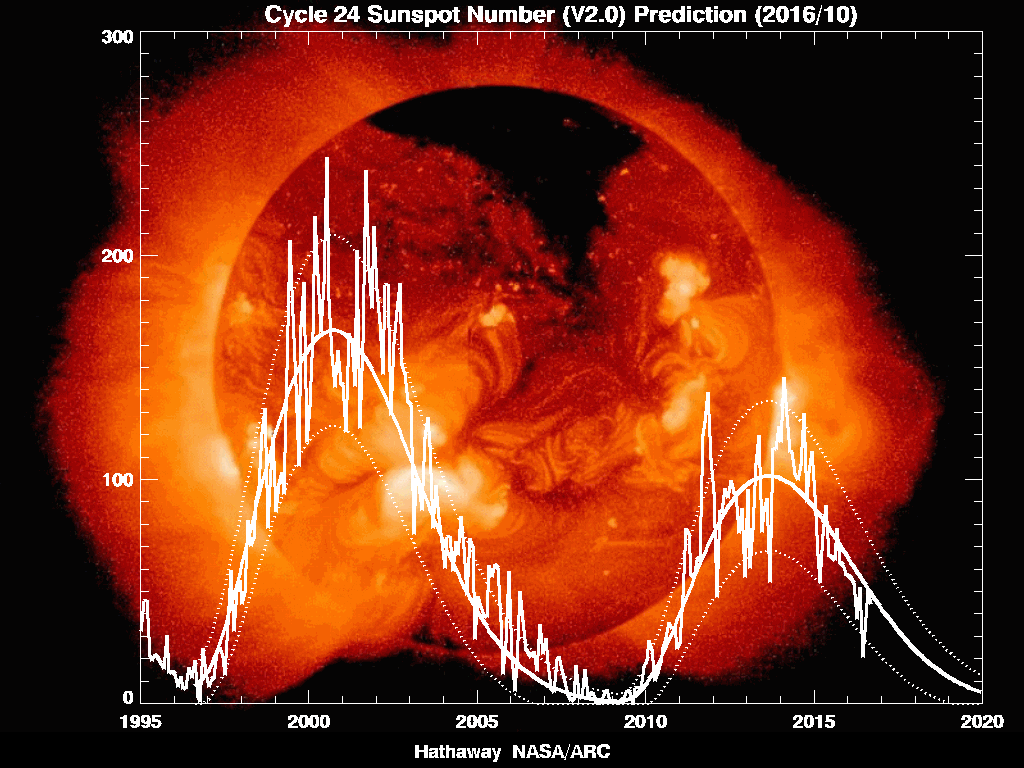
The solar activity is UP

and somewhere there will be one of corresponding intensity soon..

Remember the date I gave you .. 10 April 2008.

Veeger


Strong earthquake rocks Loyalty Islands


www.chinaview.cn 2008-04-09 22:41:06 Print

BEIJING, April 9 (Xinhua) -- An earthquake measuring 7.3 on the Richter scale hit the Loyalty Islands in the south Pacific Ocean at 20.2 degrees south and 168.9 degrees east at 8:46 p.m. on Wednesday (Beijing Time), according to the Chinese Seismological Network.

The Loyalty Islands -- an archipelago comprising the islands of Lifou, Mare, Ouvea and Tiga -- are part of the French territory of New Caledonia, lying about 100 kilometers east of the mainland.

7.3 Earthquake Among Series To Hit South Pacific

CBS 5 Earthquake Section

VANUATU (CBS 5) ― A series of earthquakes has rocked an area of the South Pacific, the strongest being a 7.3 magnitude Wednesday morning, according to the U.S. Geological Survey.

At least 7 earthquakes of magnitude 5.0 or greater have occurred in the last 12 hours, according to the USGS website.

The earthquake have all hit about 50 miles southwest of Vanuatu, and 120 miles northeast of the Loyalty Islands.

The 7.3 earthquake struck at 5:46am Pacific Time, 11:46pm local time.

The Pacific Tsunami Warning Center said while no widespread tsunami threat exists, earthquakes of such size could at times generate local tsunamis that can be destructive along coasts within 62 miles of the epicenter.

The Alaska Tsunami Warning Center said a tsunami was not expected along the west coast.

There have been no reports of damage or injuries.

(© MMVIII, CBS Broadcasting Inc. All Rights Reserved.)


April 06, 2008

More on Solar Cycle 23 and 24 ..

Old Solar Cycle Returns

http://solarscience.msfc.nasa.gov/images/ssn_predict_l.gif

_______________________________________________________________________________________________________Old Solar Cycle Returns

Sunspot counts vs. year: 2008 is a low point in the solar cycle. Smoothed curves are predictions of future activity.
by Dr. Tony Phillips
Huntsville AL (SPX) Mar 31, 2008rned. (Actually, itver left. Read on.) “This week, three big sun

What’s going on? Hathaway explains: “We have two solar cycles in progress at the same time. Solar Cycle 24 has begun (the first new-cycle spot appeared in January 2008), but Solar Cycle 23 has not ended.”

read more:

http://www.spacedaily.com/reports/Old_Solar_Cycle_Returns_999.html

April 01, 2008

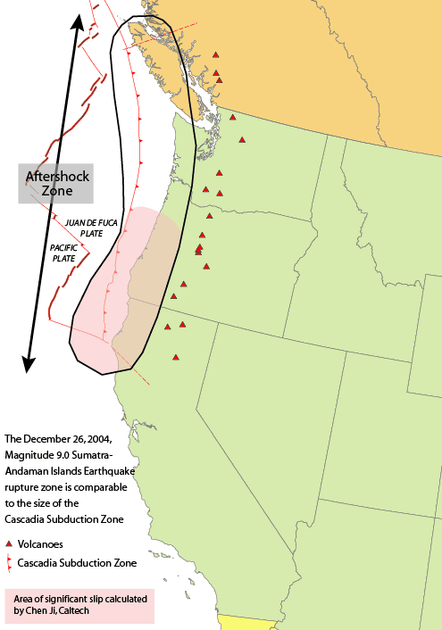
Mega-quake risk to rise in April (Cascadia subduction zone)


COLLIDING PLATES

http://thepowerhour.com/news.htm

The chances of a massive earthquake striking B.C.’s south coast will be somewhat higher than normal in April.

Seismologists project the region will soon enter another period of what they call “episodic tremor and slip” (ETS) activity.

ETS periods happen every 14 months and are marked by more small tremors and increased movement as the Juan de Fuca plate grinds underneath the North American plate along what’s known as the Cascadia subduction zone.

The fault that slopes down beneath Vancouver Island comes under increased pressure at such times and that’s also when seismologists think it’s more likely there could be a major movement of the plates, causing a “megathrust” earthquake.

“Each time we have one of these events an increment of stress gets added,” explained Garry Rogers, an earthquake scientist with the Geological Survey of Canada.

“So it’s like a staircase and we go up the staircase one step or we add a straw to the camel’s back. At some point the camel’s back is going to break and we think that rather than at some random time it will break when you add a straw.”

The result will be a giant subduction zone quake of magnitude 9 or more, likely coupled with a potentially devastating tsunami.

That type of earthquake last struck on Jan. 26, 1700, wiping out aboriginal villages and sending a tsunami across the Pacific that devastated Japan.

Rogers said the current forecast is for a two-week ETS period to occur around mid-April.

While he said it brings a “small increase in probability of a subduction earthquake” it’s not yet considered a useful way to forecast seismic risk or predict when earthquakes will strike – the holy grail of seismology.

“We’re a long ways from that yet,” he said. “But it’s got all kinds of people excited and all kinds of people pursuing research in that direction.”

The challenge is that since the first discovery of the ETS phenomenon here by a team of scientists including Rogers, similar patterns have been detected along fault lines elsewhere.

And the Cascadia subduction zone underneath B.C.’s coast doesn’t operate in isolation – it extends south all the way to California.

“Cascadia mostly fails in giant magnitude 9 earthquakes that rupture the entire 1,000-kilometre subduction zone rather than in smaller earthquakes affecting only certain regions,” Rogers explained.

ETS activity in other parts of the fault often happens at different times than in B.C. An 11-month cycle has been observed in California, for instance,

That means the super quake could start off Oregon or California rather than here, but rip its way up the coast to B.C. even when this area might be in a theoretical “safer” time.

About a third of the time some portion of the zone is undergoing increased ETS stress, Rogers added.

“If we knew where it was going to start then this would be very significant,” he said, but added it’s still a “giant leap in understanding.”

Rogers doesn’t advise his friends or family to head for safer ground at riskier times.

“Stay around – it could be exciting,” he joked.

He stressed the more probable source of major damage here is not an extremely rare and deep underground “monster” subduction quake, but rather more common earthquakes that are less powerful but felt more intensely because they happen closer to the surface.

They include quakes like ones in 1918 and 1946 on Vancouver Island, as well as the magnitude 6.9 earthquake in Kobe, Japan that killed 4,600 people and caused $200 billion of damage in 1995.

“Putting an earthquake like that next to an urban community would cause humongous damage,” he said.

Episodic tremor and slip activity gives no insight into when that type of quake could strike, he said.

Statistically, he added, there’s about a 20 per cent chance of a close, damaging quake happening over the course of a lifetime.

COLLIDING PLATES

To find out what’s going on 30 kilometres beneath Vancouver Island, researchers rely on help from 20,000 kilometres overhead.

A network of GPS satellites are used to precisely track the movement of monitoring stations on the ground.

Vancouver Island usually moves east a few millimetres per year.

But the instruments show that every 14 months at episodic tremor and slip (ETS) periods, the monitoring sites reverse direction and and travel west towards Japan several centimetres over the course of two weeks.

The movement is the result of the slipping of the offshore Juan de Fuca plate underneath the North American plate.

WHAT YOU CAN DO

- Be ready for disaster with a ready-to-go emergency kit and enough food and water stockpiled to last a minimum of 72 hours.

source:
http://www.bclocalnews.com/surrey_area/surreyleader/news/17034006.html
_____________________________________________________________________________________

Image:Cascadia subduction zone USGS.png

en:Cascadia subduction zone.

March 20, 2008

update: Kerch Strait oil spill

Too bad I have no regular readers! Cuz this is a followup of a story I covered.

Why did I cover it?

Becuz the Russians are just MORE and BIGGER earth polluters than many.

Look at this mess! Very very scary stuff. Money will NOT bring back those dead birds.

It rivals the mess made in Korea .. the one the NYT's doesn't bring up anymore that will take 12 YEARS minimum to fix ..

And do you REALLY think that Russia will play fair and protect marine life at Sakhalin-2 as pressure for oil and gas crank up? Probably not, unless people MAKE them.

Support your local environmentalist organizations on these issues.

Time is running short to keep any water clean, anywhere ..

Have no fear that they don't have the money to pay!! The Russian mob just ripped off $8 bn from SocGen and that's just one of the plots to keep that ole Treasury over in Moskva propped up. Just the "cost of doing business" ..

Hey! I give a monthly donation to Greenpeace? How about YOU? I am PROUD to do so, too. They don't just hunt whales, you know.

Veeger


Ukraine to charge Russia $1bln for Kerch Strait oil spill

12:25 | 19/ 03/ 2008

SIMFEROPOL, March 19 (RIA Novosti) - Ukraine plans to charge Russian ship-owners over $1 billion in damages for a November fuel oil spill in the Kerch Strait, the press office of the Ukrainian government said on Wednesday.

A storm in the Kerch Strait, which joins the Black Sea and the Sea of Azov, sank four ships and an oil tanker on November 11. The incident resulted in about 2,000 metric tons of fuel oil spilling into the sea.

Experts said petrochemical concentrations in the Kerch Strait following the storm were 50 times higher than maximum permissible levels. Some 50,000 birds have so far died as a result of the oil slick. The fuel penetrates birds' plumage causing hypothermia, and is ingested, usually with fatal results.

Russian First Deputy Prime Minister Sergei Ivanov claimed late in December that all traces of November's disaster in the Kerch Strait had been eliminated, but Greenpeace said the consequences of fuel spill in the Kerch Strait could take up to a decade to be eliminated.

The government of Ukraine's Black Sea autonomy of Crimea has allocated 2 million hryvna ($400,000) for disposal of spilled fuel collected in the Kerch Strait.


March 18, 2008

New wooble graphic!!

Via Michael Mandeville!!


EARTH'S WOBBLE - POLAR MOTION
: Spin Axis, Magnetic Poles

Links to: ALMANAC | WOBBLE GALLERY | EARTH MONITOR

[3-18-08 ECB] POLAR MOTION: No change from prior weeks. There remains some apparent tendency to truncation of the spiral track on the Y Axis. Movement up and down the X Axis appears slightly easier for the Earth's crust than than movement on the Y Axis. This pattern we have been observing since the wobble "freeze" of January 2005.

[2-18-08 ECB] POLAR MOTION: The track now shows some outward expansion as one would expect.

[2-11-08 ECB] POLAR MOTION: Polar Motion apparently is now deviating once again from a normal track. What has been a smooth outward expansion since March 2006 is now apparently too truncated to be called an expansionary spiral. It is "retarded" and parallels far too closely the spiral track of 14 months ago. It should be showing progressive enlargement, but this is no longer evident. There are two possible explanations. One is that this Seven Year Wobble Cycle will be smaller than normal (which happens frequently). Another possible explanation is that the Wobble is merely showing us that significant drift in the average location of the center of the wobble has been and is still underway, such that the spiral center is now drifting towards the left bottom of the chart (down towards about Longitude West 70-80). This the Wobble has also done before. A third possibility is that both factors are in play. Stay tuned, the Wobble continues to be more dynamic than anyone previously imagined.

[1-28-08 ECB] POLAR MOTION: As reported January 27 in the "Pivot Point" Bulletin (see Yahoo Archives), the Earth was apparently at tectonic standstill on Saturday/Sunday (almost 0 seismic activity 4+, ultra-low activity in the range of 2.5-4)) while the Earth's tilted axis orientation (fixed on Polaris) began to recede from the orbital Perihelion point and thus begin the shift of the orientations of the Northern and Southern Hemispheres toward the Sun. Otherwise, no significant change from previous reports. The Spiral Track of Earth's Wobble continues to expand outward in a stable pattern. As can be expected (by looking at the history of the Wobble Track), the Earth's Wobble is currently receiving a boost of energy from the Earth's Perihelion moment with the Sun. Since the Earth is closer to the Sun at this moment, solar gravity is tugging in phase slightly more strongly on the heavy side of the Earth (the Southern Hemisphere). As a result the track of Polar Motion is now clearly showing a marked acceleration in the outward, expansionary movement of its spiral track. This is all normal. The Spin Axis is currently located in the longitude quadrant of the Russian Far East moving rapidly towards Alaska..

[11-12-07 ECB] WOBBLE TRACKER SOFTWARE IMPROVED. Davis Chapman graciously upgraded the WobbleTracker Software in a way which makes it easier to use and more analytically powerful for plotting exact date sequences. Anyone who has previously purchased WobbleTracker is eligible for an upgrade which I will email as a zip file.

Mouse arrow cursor points toward the latest location of Spin Axis

Image is from WobbleTracker software, drawn by MWM

Graph Scale is set to 1.0 arcseconds, Grid Size = 0.05 arcseconds
Time Domain as shown in upper right hand corner
.
All movement is counter-clockwise.

This chart shows the location of the North Spin Axis relative to the “map coordinates” which were established at the end of the 19th century. A drift of over 50 feet since 1900 in the circular track of Chandler’s Wobble is shown in this chart. This drift is the primary cause of the acceleration in Earth’s tectonic activity. In order to “parallel” the way in which geophysicists create and record the Earth’s polar location geo-reference system, this graph shows the negative numbers opposite to the manner which they are typically drawn in school books. –X is shown on the top half, and this corresponds to the direction of the Pacific Hemisphere. –Y is shown on the right side and this corresponds to the Eurasian Land Mass. X= Longitude 0, which is the Greenwich Meridian which bisects through England; +Y= Longitude West 90, which bisects through the Great Lakes (North America).


ShareThis