Showing posts with label tech plates. Show all posts

April 09, 2008

== PRELIMINARY EARTHQUAKE REPORT ==

***This event supersedes event AT00774517.


Region: LOYALTY ISLANDS
Geographic coordinates: 20.208S, 168.808E
Magnitude: 7.5 Mw
Depth: 88 km
Universal Time (UTC): 9 Apr 2008 12:46:18
Time near the Epicenter: 9 Apr 2008 23:46:18
Local standard time in your area: 9 Apr 2008 12:46:18

Location with respect to nearby cities:
89 km (55 miles) SSW (213 degrees) of Isangel, Vanuatu
174 km (108 miles) NE (34 degrees) of Tadine, Loyalty Islands, New Caledonia
278 km (173 miles) S (169 degrees) of PORT-VILA, Vanuatu
1798 km (1117 miles) ENE (67 degrees) of Brisbane, Australia


ADDITIONAL EARTHQUAKE PARAMETERS
________________________________
event ID : US 2008qqa2

This event has been reviewed by a seismologist at NEIC
For subsequent updates, maps, and technical information, see:
http://earthquake.usgs.gov/eqcenter/recenteqsww/Quakes/us2008qqa2.php
or
http://earthquake.usgs.gov/

National Earthquake Information Center
U.S. Geological Survey
http://neic.usgs.gov


Try enlarging the image!!

The one on the left is the IMPORTANT ONE.

It shows the long term effects of the tech plates moving ..

The solar activity is UP

and somewhere there will be one of corresponding intensity soon..

Remember the date I gave you .. 10 April 2008.

Veeger


Strong earthquake rocks Loyalty Islands


www.chinaview.cn 2008-04-09 22:41:06 Print

BEIJING, April 9 (Xinhua) -- An earthquake measuring 7.3 on the Richter scale hit the Loyalty Islands in the south Pacific Ocean at 20.2 degrees south and 168.9 degrees east at 8:46 p.m. on Wednesday (Beijing Time), according to the Chinese Seismological Network.

The Loyalty Islands -- an archipelago comprising the islands of Lifou, Mare, Ouvea and Tiga -- are part of the French territory of New Caledonia, lying about 100 kilometers east of the mainland.

7.3 Earthquake Among Series To Hit South Pacific

CBS 5 Earthquake Section

VANUATU (CBS 5) ― A series of earthquakes has rocked an area of the South Pacific, the strongest being a 7.3 magnitude Wednesday morning, according to the U.S. Geological Survey.

At least 7 earthquakes of magnitude 5.0 or greater have occurred in the last 12 hours, according to the USGS website.

The earthquake have all hit about 50 miles southwest of Vanuatu, and 120 miles northeast of the Loyalty Islands.

The 7.3 earthquake struck at 5:46am Pacific Time, 11:46pm local time.

The Pacific Tsunami Warning Center said while no widespread tsunami threat exists, earthquakes of such size could at times generate local tsunamis that can be destructive along coasts within 62 miles of the epicenter.

The Alaska Tsunami Warning Center said a tsunami was not expected along the west coast.

There have been no reports of damage or injuries.

(© MMVIII, CBS Broadcasting Inc. All Rights Reserved.)


April 01, 2008

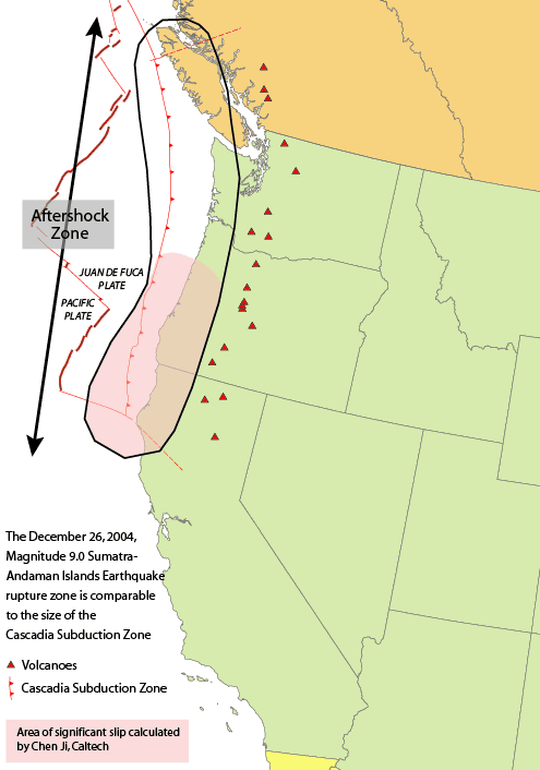
Mega-quake risk to rise in April (Cascadia subduction zone)


COLLIDING PLATES

http://thepowerhour.com/news.htm

The chances of a massive earthquake striking B.C.’s south coast will be somewhat higher than normal in April.

Seismologists project the region will soon enter another period of what they call “episodic tremor and slip” (ETS) activity.

ETS periods happen every 14 months and are marked by more small tremors and increased movement as the Juan de Fuca plate grinds underneath the North American plate along what’s known as the Cascadia subduction zone.

The fault that slopes down beneath Vancouver Island comes under increased pressure at such times and that’s also when seismologists think it’s more likely there could be a major movement of the plates, causing a “megathrust” earthquake.

“Each time we have one of these events an increment of stress gets added,” explained Garry Rogers, an earthquake scientist with the Geological Survey of Canada.

“So it’s like a staircase and we go up the staircase one step or we add a straw to the camel’s back. At some point the camel’s back is going to break and we think that rather than at some random time it will break when you add a straw.”

The result will be a giant subduction zone quake of magnitude 9 or more, likely coupled with a potentially devastating tsunami.

That type of earthquake last struck on Jan. 26, 1700, wiping out aboriginal villages and sending a tsunami across the Pacific that devastated Japan.

Rogers said the current forecast is for a two-week ETS period to occur around mid-April.

While he said it brings a “small increase in probability of a subduction earthquake” it’s not yet considered a useful way to forecast seismic risk or predict when earthquakes will strike – the holy grail of seismology.

“We’re a long ways from that yet,” he said. “But it’s got all kinds of people excited and all kinds of people pursuing research in that direction.”

The challenge is that since the first discovery of the ETS phenomenon here by a team of scientists including Rogers, similar patterns have been detected along fault lines elsewhere.

And the Cascadia subduction zone underneath B.C.’s coast doesn’t operate in isolation – it extends south all the way to California.

“Cascadia mostly fails in giant magnitude 9 earthquakes that rupture the entire 1,000-kilometre subduction zone rather than in smaller earthquakes affecting only certain regions,” Rogers explained.

ETS activity in other parts of the fault often happens at different times than in B.C. An 11-month cycle has been observed in California, for instance,

That means the super quake could start off Oregon or California rather than here, but rip its way up the coast to B.C. even when this area might be in a theoretical “safer” time.

About a third of the time some portion of the zone is undergoing increased ETS stress, Rogers added.

“If we knew where it was going to start then this would be very significant,” he said, but added it’s still a “giant leap in understanding.”

Rogers doesn’t advise his friends or family to head for safer ground at riskier times.

“Stay around – it could be exciting,” he joked.

He stressed the more probable source of major damage here is not an extremely rare and deep underground “monster” subduction quake, but rather more common earthquakes that are less powerful but felt more intensely because they happen closer to the surface.

They include quakes like ones in 1918 and 1946 on Vancouver Island, as well as the magnitude 6.9 earthquake in Kobe, Japan that killed 4,600 people and caused $200 billion of damage in 1995.

“Putting an earthquake like that next to an urban community would cause humongous damage,” he said.

Episodic tremor and slip activity gives no insight into when that type of quake could strike, he said.

Statistically, he added, there’s about a 20 per cent chance of a close, damaging quake happening over the course of a lifetime.

COLLIDING PLATES

To find out what’s going on 30 kilometres beneath Vancouver Island, researchers rely on help from 20,000 kilometres overhead.

A network of GPS satellites are used to precisely track the movement of monitoring stations on the ground.

Vancouver Island usually moves east a few millimetres per year.

But the instruments show that every 14 months at episodic tremor and slip (ETS) periods, the monitoring sites reverse direction and and travel west towards Japan several centimetres over the course of two weeks.

The movement is the result of the slipping of the offshore Juan de Fuca plate underneath the North American plate.

WHAT YOU CAN DO

- Be ready for disaster with a ready-to-go emergency kit and enough food and water stockpiled to last a minimum of 72 hours.

source:
http://www.bclocalnews.com/surrey_area/surreyleader/news/17034006.html
_____________________________________________________________________________________

Image:Cascadia subduction zone USGS.png

en:Cascadia subduction zone.

ShareThis