November 30, 2010
More Indonesian volcanoes getting restless
November 29, 2010
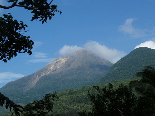
Bulusan explodes
Inquirer.net
2010-11-27 13:56:00
Inquirer.net
2010-11-27 13:56:00
![]() |
Legazpi City -- An "explosion-type" earthquake was recorded by the Philippine Institute of Volcanology and Seismology in in Sorsogon Friday night.
In its latest bulletin, Phivolcs said that the quake occurred at around 7:27 p.m. and lasted for about 11 minutes. Clouds, however, prevented state volcanologists to visually observe it.
The statement did not say what distinguished an "explosion-type" earthquake from any other volcanic tremor.
Sulfur dioxide emission rate was measured at 13 tons per day.
About 11 volcanic quakes were also recorded by the seismic network around the volcano during the past 24-hour observation period.
Phivolcs said Bulusan's status remained at alert level 1 and the public was reminded not to venture into the four-kilometer permanent danger zone as sudden steam and ash explosions may occur.
Legazpi City -- An 'explosion-type' earthquake was recorded by the Philippine Institute of Volcanology and Seismology in in Sorsogon Friday night.
In its latest bulletin, Phivolcs said that the quake occurred at around 7:27 p.m. and lasted for about 11 minutes. Clouds, however, prevented state volcanologists to visually observe it.
The statement did not say what distinguished an 'explosion-type' earthquake from any other volcanic tremor.
Sulfur dioxide emission rate was measured at 13 tons per day.
About 11 volcanic quakes were also recorded by the seismic network around the volcano during the past 24-hour observation period.
Phivolcs said Bulusan's status remained at alert level 1 and the public was reminded not to venture into the four-kilometer permanent danger zone as sudden steam and ash explosions may occur."
November 15, 2010
October 26, 2010
Watch the Ring of Fire! Merapi is erupting
One of those who died on Tuesday was a baby who suffered breathing problems, while another 30 people have been injured.
Surono, the government's chief volcanologist, said the mountain, which had been rumbling for hours, started to erupt just before dusk, a day after the agency raised the alert status to the highest level.
"We heard three explosions around 06:00 pm (1100GMT) spewing volcanic materials as high as 1.5 km upward and heatclouds down on the slopes," Surono, who like many Indonesians goes by only one name, told the AFP news agency.
Indonesian scientists had warned of a pressure build-up beneath Mount Merapi's lava dome, as authorities evacuated tens of thousands of villagers to temporary shelters.
Rock avalanche
An avalanche of rocks spilled down Merapi's slopes before dawn on Tuesday and gusts of ash rose 50 metres into the air as the mountain continued to rumble.
Surono had said earlier that the greatest concern was pressure building behind a massive lava dome that has formed near the tip of the crater.
"The energy is building up. ... We hope it will release slowly," he said.
"Otherwise, we're looking at a potentially huge eruption, bigger than anything we've seen in years."
Temporary shelters were set up after officials designated an area 10km around the country's most active volcano a danger zone.
More than 50,000 people living in the shadows of the volcano, located north of the Javanese cultural capital, Jogjakarta, are now facing evacuation.
Widi Sutikno, a field co-ordinator in the Sleman district on the southern slopes of the 2,914-metre mountain, said about 3,700 people had already moved to makeshift camps.
"We have evacuated many women, pregnant women, sick people, elderly people and children," Sutikno said.
"We let some people return to their fields for their daily activity. But they need to go back to the camps and not their houses."
Huge panic
Step Vassen, Al Jazeera's correspondent close to Mount Merapi, said: "There was huge panic of course when the eruption was taking place.
"Two women are in hospital with severe wounds due to the hot gas clouds that came down from the mountain that can reach 600 degrees Celsius, so they are very dangerous.
"Now thousands of people are running away, they are trying to find a safer place. They are going to the refugee centres that have been set up by the government."
Vassen said that as Merapi is the most active volcano in the country residents were reluctant to leave for fear of leaving homes and livestock unattended for a false alarm.

Merapi last erupted in 2006, when it sent an avalanche of pyroclastic ash - hot gases and rock fragments - racing down the mountain which killed two people.
A similar eruption in 1994 killed 60 people, while 1,300 people died in an eruption in 1930.
There are more than 129 active volcanoes in Indonesia, which are spread across 17,500 islands and prone to eruptions and earthquakes due to its location within the so-called Ring of Fire.
The ring comprises a series of fault lines stretching from the western Hemisphere through Japan and Southeast Asia.
April 09, 2008
== PRELIMINARY EARTHQUAKE REPORT ==
***This event supersedes event AT00774517.
Region: LOYALTY ISLANDS
Geographic coordinates: 20.208S, 168.808E
Magnitude: 7.5 Mw
Depth: 88 km
Universal Time (UTC): 9 Apr 2008 12:46:18
Time near the Epicenter: 9 Apr 2008 23:46:18
Local standard time in your area: 9 Apr 2008 12:46:18
Location with respect to nearby cities:
89 km (55 miles) SSW (213 degrees) of Isangel, Vanuatu
174 km (108 miles) NE (34 degrees) of Tadine, Loyalty Islands, New Caledonia
278 km (173 miles) S (169 degrees) of PORT-VILA, Vanuatu
1798 km (1117 miles) ENE (67 degrees) of Brisbane, Australia
ADDITIONAL EARTHQUAKE PARAMETERS
________________________________
event ID : US 2008qqa2
This event has been reviewed by a seismologist at NEIC
For subsequent updates, maps, and technical information, see:
http://earthquake.usgs.gov/eqcenter/recenteqsww/Quakes/us2008qqa2.php
or
http://earthquake.usgs.gov/
National Earthquake Information Center
U.S. Geological Survey
http://neic.usgs.gov
Try enlarging the image!!
The one on the left is the IMPORTANT ONE.
It shows the long term effects of the tech plates moving ..
The solar activity is UP
and somewhere there will be one of corresponding intensity soon..
Remember the date I gave you .. 10 April 2008.
Veeger
Strong earthquake rocks Loyalty Islands |
| www.chinaview.cn |
BEIJING, April 9 (Xinhua) -- An earthquake measuring 7.3 on the Richter scale hit the Loyalty Islands in the south Pacific Ocean at 20.2 degrees south and 168.9 degrees east at 8:46 p.m. on Wednesday (Beijing Time), according to the Chinese Seismological Network.
The Loyalty Islands -- an archipelago comprising the islands of Lifou, Mare, Ouvea and Tiga -- are part of the French territory of New Caledonia, lying about 100 kilometers east of the mainland.
7.3 Earthquake Among Series To Hit South Pacific
CBS 5 Earthquake Section
VANUATU (CBS 5) ― A series of earthquakes has rocked an area of the South Pacific, the strongest being a 7.3 magnitude Wednesday morning, according to the U.S. Geological Survey.At least 7 earthquakes of magnitude 5.0 or greater have occurred in the last 12 hours, according to the USGS website.
The earthquake have all hit about 50 miles southwest of Vanuatu, and 120 miles northeast of the Loyalty Islands.
The 7.3 earthquake struck at 5:46am Pacific Time, 11:46pm local time.
The Pacific Tsunami Warning Center said while no widespread tsunami threat exists, earthquakes of such size could at times generate local tsunamis that can be destructive along coasts within 62 miles of the epicenter.
The Alaska Tsunami Warning Center said a tsunami was not expected along the west coast.
There have been no reports of damage or injuries.
(© MMVIII, CBS Broadcasting Inc. All Rights Reserved.)